
The Aitken Basin, located on the far side of the Moon near the south pole, has an fascinating environment. It is the deepest impact crater on the moon, with a nadir elevation of at least -12 km relative to the surrounding lunar landscape. It is usually completely dark, having a temperature of about 40-50 Kelvin, or about negative 230 to negative 220 degrees Celsius. Also, since it is almost entirely dark, it is usually hard to see such things as topographical features without using a near-infrared light filter, which detects near-infrared electromagnetic waves. These waves are a slightly lower frequency than the visible light spectrum, and this filter allows us to see the rough height of features on the moon’s surface. Pictured below is a color-coded, topographic of terrain near the Aitken Basin.
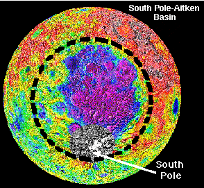
The colors represent varying elevations. The colors are are purple, blue, green, yellow, red, and gray, listed respectively from lowest to tallest. Click here for a larger view. (This image retrieved from http://www.psrd.hawaii.edu/Dec96/IceonMoon.html#graph, where it was used courtesy of Lunar and Planetary Institute).
The Aitken Basin is located at the large blue and purple region near the center of the picture. In the Aitken Basin, there is an unidentifiable dark spot. A few years ago, when a spacecraft called Clementine was sent to orbit the moon and send back findings, scientists decided to look for ice in the Aitken Basin, near the south pole. Unfortunately, when they sent the Clementine up, they did not put any equipment that would have ensured the finding (or discovering there was none) of water on the moon. Instead they improvised, using reflected radio waves. Clementine sent radio waves at the moon. Since radio waves reflect off most things, the test would show what substance was there. That is because each substance reflects radio waves in its own way. Ice would reflect light much like “a bicycle headlamp reflector” which essentially is reflecting the light from the headlamp in itself before sending it out as a slightly more focused light. (Spudis, 1996)
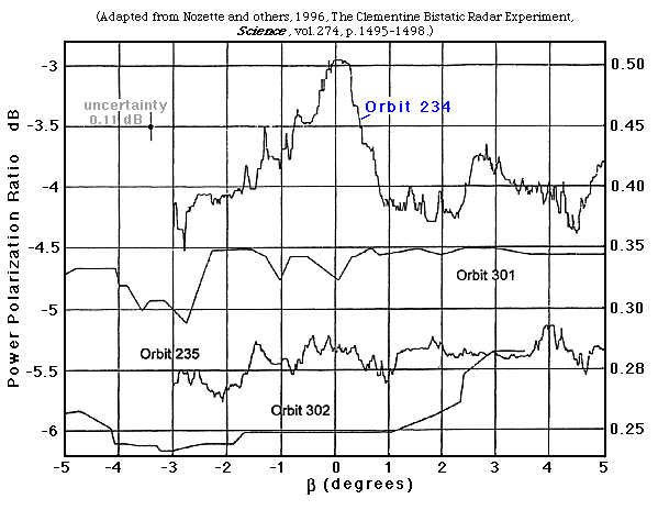
Click here for a larger view. (This image retrieved from http://www.psrd.hawaii.edu/Dec96/IceonMoon.html#graph, where it was adapted from Nozette and others, 1996, The Clementine Bistatic Radar Experiment, Science, vol. 274, p. 1495-1498).
The results are shown in the graph above. On the line labeled “Orbit 234,” you notice that as measure of degrees approaches 0, there is a peak in the Power Polarization Ratio. This is very similar, if not exactly the same, as what would happen if it was sending radio waves at ice. Orbit 234 goes over a very specific area, practically right over the spot in the center of the Aitken Basin.
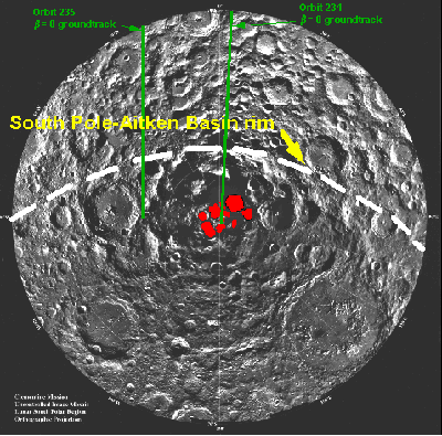
Click here for a larger view. (This image retrieved from http://www.psrd.hawaii.edu/Dec96/IceonMoon.html#graph, where it was used courtesy of Lunar and Planetary Institute, basemap from the Clementine Project; USGS image processing).
The picture above shows where you would find the ice. The red spots
show
the areas that concur with the graph for finding ice -- this is where our
robot will
search.

